| Maps |
| Mailing List |
| News |
| Weblinks |
| Octarine |
| Files |
| Dip |
 |
| Home |
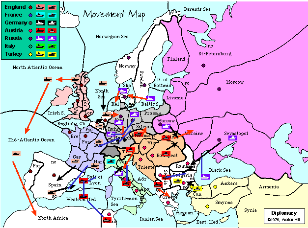
Some see it as a map to the psyche of other players, to others it may feel like charting a journey on the road map to global conquest -- what is it? It's the mapping of Diplomacy results. In my short time (so far) of playing Diplomacy, I have discovered a penchant for mapping. Text-based results don't mean much to me yet; I don't actually digest the consequences of the orders until I plot them on the map and see the movement patterns and final results. In the course of learning how the game works, and talking with others who use my maps and are mappers themselves, a couple of issues came up that seem to be diametrically opposed -- or are they, really?
In the afpdip list, I conducted a mini-survey about mapping preferences. In it, I asked two main questions: "Do you have a preference when it comes to how units are placed on a map?" And if they did, then "Do you prefer to have unobstructed province names or central unit placement?"
The heart of the issue is whether or not it is more important to keep the province name clear or place the unit smack in the middle of the borders. Of course, in some provinces it doesn't make a dingo's kidney's worth of difference, because the place is so small that you can't avoid covering the name nor can you even keep the icon within the borders at all. But for the average province, this conundrum faces mappers every phase of the game.
The act of placing abbreviations for the same province, and sometimes different names altogether for the same province, so keeping them straight can be a tad difficult.
On the side of central placement:
The main reason for preferring central unit placement was the possibility of observational bias affecting player decisions. By placing the unit icon clear of the abbreviation, one border is nearly always favoured over others. This could cause a player to perceive a greater danger to the province on the other side of that border, rather than an equal danger to all provinces within a legal move of that unit. Along with this expressed preference, the respondent felt that the province names are generally memorised after the first game-year or so, and therefore a mnemonic on the map isn't as critical.As a side-note to this survey, a discussion of the possible psychological effects of unit placement began. The question was expressed as "what if placing the unit off the coast of Bre would trigger the player thinking there was more danger there rather than with the fleets in MAO and NAf. . .?" It is a very intriguing question, but not conducive to answering, as it would take several games (with unsuspecting players, that's the important bit) with a very manipulative GM and/or mapper to get enough data.
An alternative?
An alternative to the clear name/central unit question was proffered by one afpdipper: "Is there any reason why the names of provinces has to be in the middle? Couldn't it be at the top instead leaving space for the unit underneath?" This is a very valid point, and I for one am bouncing my forehead off the display for not thinking of it myself. It would not solve the problem of postage-stamp-sized provinces (nothing but growth-hormones will do that), but for average sized provinces it could work.Most mappers create and modify their maps in an image-editing program, naturally; many use one that will allow for either layers or discrete objects. This makes moving the unit icons in response to results quite easy. I use Photoshop and a layer for each country's units, each country's movements (since I do movement-maps as well as detail-maps), a legend, the phase, and the map itself as the background. Making movable names/abbreviations would be a good afternoon's work of creating a new layer and cutting/pasting the text into it, then repairing the background map. Once done, though, would it be a snap to implement. The process would be similar for object-oriented mappers. However, for mappers who are using applications which do not support objects or layers and are modifying the base map itself, moving the province names would not work.
The downside to this -- a minor one, yes -- would be constant uncertainty as to where to find province names on the map. With layers or objects, the text could be shifted each phase to accomodate different units (or arrow lines in movement-maps). But I think this concern would only bother very new newbies to the game or variant. I'll have to try it out and see.
The upshot:
The conclusion of this survey (and the attendant discussion about map-psychology) was that a map is always to be considered 'viewer beware'. One response went so far as to say that the map should only be used as a secondary planning device; the results themselves should be considered the primary means of seeing the status of the game. However, many players do depend on the maps to see unit placements and plan strategies. Newbies, in particular, perceive the results as a mishmash of text. Even after six months of mapping, I have to read results slowly and with a map in front of me to plot the moves.Players should always keep in mind that mappers are human and can make mistakes. Depending on the map to be perfect can (will, in Diplomacy!) lead to mistakes in planning and strategy which could lead to losing all your supply-centres. Mappers cannot be blame means obscuring the province name. If someone is in doubt they can look at the blank map.
- If at all possible, the province name (and SC dot) should be visible. The colour of the SC dot takes preference as that is not constant.
- As for positioning within a province, I do take some artistic license. If a unit is forming part of a 'front' I will tend to place it near the enemy. If a unit has been making progress in a certain direction, e.g. north, I will tend to put it on the north side of the province.
- If the unit is in a big province with lots of space, I tend to put it in an aesthetically pleasing place to 'balance up' the province name.
- I will tend to drop new units on top of old units. I'm editing the gif directly, and to change the position of a unit when the ownership of a province changes takes time.
None of these are 'rules' or were even preplanned, they are just what I tend to do unconsciously... with maps I also work on the principle that if you don't like MY map then you are at liberty to make your own... as long as it's accurate, that's all I worry about.
Here are some programs recommended by various people for mapmaking.
- Corel Draw 7.0
- Object Orientated vector-based drawing package with more features than Gaspode's got fleas. OS: Win95/NT
Pro: Very professional package. Being vector-based you can rescale things to any degree after you've drawn 'em. And you get PhotoPaint & lots of other stuff.
Con: Cost ~100UKP, Superceded by CD8, hence the price drop.
All the text can be moved around as well as the units, orders, SCs and all, giving Total Flexibility in Map Making(TM). And the abbreviations & full province names are on seperate layers so I can switch 'em on or off. If you want a 24" square map to play on then it's yours without jaggies.
- Adobe Photoshop (Mac/Unix/Win)
- Commercial (LE version may be available)
Pro: layers, gif98a export, mode-changing (indexed to RGB), history palette (in v5, so's you can back up to before that incorrect arrow you drew five arrows ago), available in 16 languages besides English
Con: *pricey*, can be a bit memory intensive
Another mapmaker comments: Visions of sledgehammers and nuts are creeping up here. Of course the nice thing about Photoshop is that you could seamlessly blend in a photograph of yourself fading from left to right with the map fading from right to left THEN reformat the whole thing into a ball shape.
- http://www.gimp.org/
- The GIMP for Linux + XFree86 (and possibly X on other unices).
I don't use it myself, because I don't do much (any) graphics editing, but other people swear by it, and I understand it to be very powerufl.
And, being GNU, it is, of course, free. :-)
Another mapmaker comments: The GIMP (X-Windows), GPL (free software), everything that Adobe Photoshop has and more, loads of free plug-ins, plug-ins to enable scripting in lots of languages, plug-in support for every known file format - can even save image as an HTML table. Cost: nothing.
- M$ Powerpoint (Win32)
- Presentation graphics package. Allows the pieces to be objects that can be moved around and can store all the maps for a game in one presentation. The downside is that it only exports WMF which then needs to be converted using something like Paint Shop Pro. Expensive (unless its free nfrom work or part of a bundle)
For the record. I edit and store maps in Powerpoint then export the move/movement files to WMF. Then import to PaintshopPro to convert to gif. This may sound a pain but I reckon its twice as fast as using a graphics tool like PSP throughout.
- Paint Shop Pro (win311)
- Shareware, no layers, cheap, many file formats.
- Paint Shop Pro (win95)
- Supports layers, many fi